

Core
$1,000a month, billed annually
$1,250 month to month
As low as $0.20 per property
- Up to 5,000 properties
- 3 users
- 3 hazard families of your choice
- Alerts to unlimited recipients by email and text
- Ranked impact map
With V-Intel, your AI-native damage intelligence platform. Now live
The V-Intel map shows the whole United States with every property of a company pinned, each client's properties ringed in its own colour. The rings are switched off, then wind: its streams sweep across the country; then wildfires: 137 active fires light up the West, among the properties. The map then glides in on one property, Industrial in Newnan, Georgia, and its card opens, shown up close: severe, its worst impact a FEMA emergency declaration, inside the alert area.
Import your portfolio, see the weather reach it, and know what to inspect first, before the phone starts ringing
1
Alerts
Pick the hazards and how bad they have to be. We show what that rule would have done over the last 90 days, so your team only gets the alerts that matter.
A new notification is set up from the Flooding template. The steps move to How bad, where the severity floor is set, and then to the review. The review says in plain English which hazards the rule watches and how bad they have to be. Before anything is saved, it says the rule would have alerted 97 of 178 properties about 900 times in the last 90 days, and warns that this is a lot of messages.
2
Ranked by impact
Severity and estimated dollar exposure on every row, with the total at the top. Send the inspector to the right building first.
Estimates are a share of declared value by severity. Ranges, not appraisals.
The V-Intel map and the ranked list of properties, filtered to severe and worse. The severity filter is widened to every severity. The totals at the top change from 25 hit and $7.3M to 178 properties, 36 hit and $9.3M in estimated exposure. Each row shows the property, its worst hazard, its severity and an estimated dollar range, worst first.
3
Ask EV Agent
“Which of our Honolulu buildings were in the hurricane?” The map goes there, with the rows behind the answer. Settle a roof or capex question in a minute, not an afternoon.
A question is typed into Ask EV Agent: which properties in Honolulu were hit by a hurricane. The map moves to Honolulu and the answer lists the 7 properties behind it. The filters change to match the question: tropical storms, over the last 6 months. Hovering a property shows its card with the worst warning it was inside.
4
Business search
Pull a shape over the damage and get every business and building inside it, worst hit first
A box is drawn over Des Moines on the V-Intel map. The panel lists the 25 businesses inside it, each with its category, address and phone number. Each business is numbered on the map in the same order as the list.
5
Export business search results
Properties, incidents and exposure export at the size you choose, for your insurer, your lender or Monday's ops call
From the businesses inside a drawn area, Export CSV opens a menu: these 25, the top 100, the top 500 or all 3,406. “These 25” is chosen and the file downloads. The file opens as a spreadsheet with each business's rank, name, category, phone number, address and city.
6
Upload your properties
We read the columns, geocode every address and show you what we found before anything saves. No integration project, no data team.
A five-row spreadsheet is dropped into the importer. V-Intel reads the columns, geocodes every address, and shows a report of what it found and what it tidied before anything saves. Import adds the five properties, and the map shows them with today's weather on them.











Industry partners


The alerts are descriptive, timely, and comprehensive, making it easy to stay informed. Thanks to the alerts, I've secured around $2 million worth of work.
I worked with the entire Earthvisionz team for over 6 years while I was leading digital product development efforts at the PGA TOUR. We engaged with them to build out the first ever live map experience.
Helping our customers prepare for potential disasters ahead of time is essential, and Earthvisionz is an extremely valuable part of that process. Their alerts provide accurate, real-time information that helps us and our customers stay informed.
Earthvisionz provides real-time weather information and communication for ATI and, more importantly, our clients.
Know which of your properties a storm just hit, how bad, and what it's worth
See how it works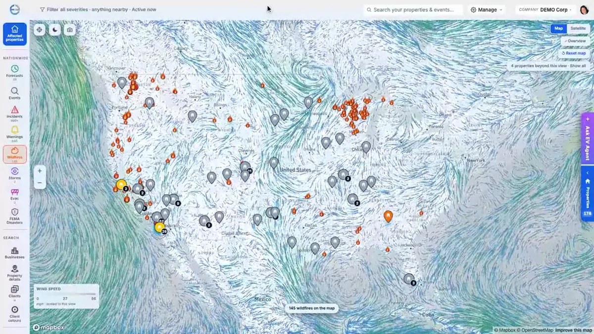
Route optimization and GPS tracking for field teams
Learn moreAutomated disaster alerts for property professionals
Learn moreA real-time IoT platform for situational awareness across your assets
Learn moreManage field crews during disaster response
Learn morePlans start at $1,000/mo. 14-day free trial with All-In features.
Founding customers: the first 20 lock in launch pricing for 2 years, and we help you set up in your first week.
Know which buildings to inspect first, before the tenant calls or the claim lands.
$1,000a month, billed annually
$1,250 month to month
As low as $0.20 per property
$1,166a month, billed annually
$1,458 month to month
From $20,000a year
Need something specific? You can also set custom alerts for specific properties, like snow, fire, hail or thunderstorms. Available on request.
Talk to the team14 days free once your spot opens. Pick your plan. We email you on day 12. Cancel in one click.
| Vendor | What you get | Published price | Per location per year | V-Intel |
|---|---|---|---|---|
| FireSignal | Fire dispatch, 1 county | $299/mo + $79 per user | By county | Every hazard, nationwide |
| FirstLeads | Fire and water leads, 5 to 10 counties | $697 to $1,497/mo | By county | 140+ alert types, same price band |
| HailStrike | Hail, 300 monitored sites | $249/mo | $9.96 | $2.40 on Core |
| HailMate | Hail maps and CRM | $79 to $499/mo | By state | Hail plus flood, fire, snow and wind |
| Baron Threat Net | Weather alerts, 10 locations per user | $918/yr per user | $91.80 | $1.00 to $2.40 |
| AccuWeather, DTN, Tomorrow.io | Enterprise weather risk | Not published, annual contract | Quote only | Every price published, AI Meteorologist included |
Prices as published on each vendor's site or public contract, October 2026.
Our current onboarding cohort is full
Next cohort opens November 1, 2026